The Ghab Plain on the Orontes
A 63-kilometre rift valley north-west of Hama, drained from marsh to farmland after 1953. Apamea and Abu Qubays castle look down on it from either side.
- Opening hours
- Open country, all day
- Entry
- Free
- Duration
- 150 minutes
- Best time
- Spring, while the fields are green and before the summer heat
- Period
- Natural rift valley; drained after 1953
- Address
- Al-Suqaylabiyah district, Hama governorate
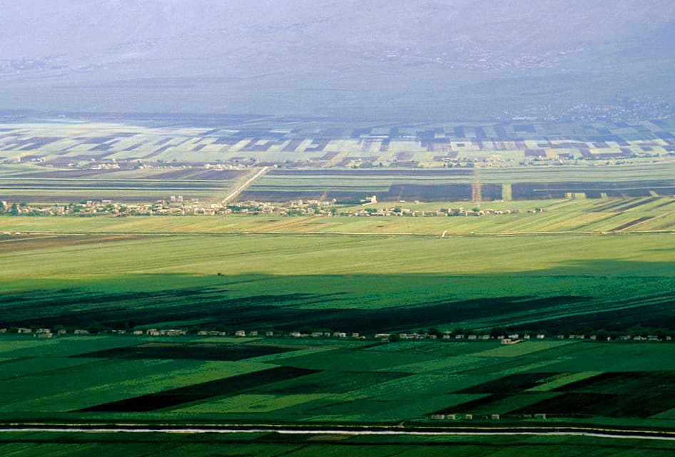
The Ghab is a rift valley north-west of Hama, running between the Nusayriyah mountains to the west and Jabal al-Zawiya to the east. The Orontes flows north through it. The plain is 63 kilometres long and a little over 12 kilometres wide. For centuries the river’s floods kept it a marsh; a project begun in 1953 drained it and turned it into farmland. There is no single monument to see here. What you get is a flat green floor cut by canals between two mountain ridges, with castles lined up along its edges.
Where the plain begins
The Orontes enters the plain near Mhardeh, about 25 kilometres north-west of Hama. Most of the Ghab lies in the al-Suqaylabiyah district; al-Suqaylabiyah became the seat of the newly created Ghab district in 1964. To the north-east there is a separate, smaller depression, the al-Ruj plain.
How a marsh became farmland
Before the drainage, the Ghab was the centre of catfish fishing in the Orontes valley. The fish is the wels catfish, Silurus glanis; locally it is called “sallor” or “samak aswad”, the black fish.
The Ghab project started in 1953. Dykes, irrigation channels and drainage canals won 41000 hectares of irrigable land, and dams went up at villages such as Mhardeh, Zayzun and Qarqur. Once the water was gone, a road and a railway could cross the plain, and malaria retreated.
The Mhardeh dam is 40 metres high and 200 metres long, holding 65 million cubic metres. The Zayzun dam, built in 1996, was 32 metres high and held 71 million cubic metres. In June 2002 it failed through a breach in its body: between 20 and 27 people died, depending on the source, more than 2000 were displaced and 80 square kilometres of land went under water.
Where to see it from
Crossing the Ghab, you cannot really read how flat and wide it is; from the high ground on its edges it makes sense at a glance. On the eastern rim stand Apamea and Qalaat al-Madiq, on the western slope of the Nusayriyah is Abu Qubays castle, and inside the plain on the Orontes rises the double mound of Tell Qarqur. All four look over the Ghab, and the road to any one of them passes the others.
How long it takes
Driving the plain from south to north and stopping at one or two viewpoints takes about two and a half hours. Combined with Apamea or Abu Qubays it fills a full day.
What most people miss
The view down from Abu Qubays castle. It sits on the eastern slope of the Nusayriyah, directly above the Ghab. Below are fields ruled into strips by the canals, and across the valley the ridge of Jabal al-Zawiya; from up there it is easy to see why the plain once held water like a lake.
Tips
- The width of the plain does not show from ground level; climb to a high point on the edge such as Abu Qubays or Qalaat al-Madiq
- Apamea, Qalaat al-Madiq and Tell Qarqur all sit on the edge of the plain; a trip to one leaves room for the others the same day
- Mhardeh is at the southern entrance to the plain and makes a natural first stop coming from Hama
Transparency
- How this was chosen
- Written by hand; opening hours, entry fee and coordinates are kept as data. A field that is not known for certain is marked as variable rather than guessed.
- Facts checked
- September 2026
- Last updated
- September 15, 2026