Tell Ashtara, Biblical Ashtaroth
A mound 4 km south-west of al-Shaykh Saad: Astartu of the Amarna letters, Ashtaroth of King Og of Bashan. You see the mound and plain; access is unverified.
- Opening hours
- Open ground; access unverified
- Entry
- Variable — confirm locally
- Duration
- 30 minutes
- Best time
- Spring, while the plain is green and before the summer heat
- Period
- Bronze Age — Iron Age
- Address
- About 4 km south-west of al-Shaykh Saad, Daraa Governorate
A mound in the north-west of the Hauran plain, about 4 kilometres south-west of the village of al-Shaykh Saad. A Bronze Age town stood here, and its name turns up in Egyptian, Assyrian and biblical texts: Astartu in the Amarna letters, the clay-tablet correspondence of Egypt’s rulers, and Ashtaroth in the Bible. There is no ruin trail waiting for the visitor; what you see is the mound itself and the plain around it. This page explains why that hill appears so often in the sources.
Ashtaroth in the texts
The town appears twice in the Amarna letters: in EA 197, a complaint by Biryawaza, governor of Damascus, and in EA 256. A letter to the pharaoh from Ayyab, who ruled the town, also survives as EA 364. Earlier still, the annals of Thutmose III at Karnak list “Astarot” among the places taken. In the Bible, Ashtaroth is the capital of Og, king of Bashan, and that town is identified with Tell Ashtara.
The Nimrud relief
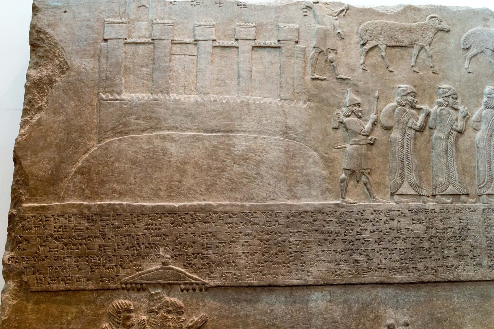
The best-known image of Ashtaroth is in London. A stone panel that Layard dug up at Nimrud in 1851, now in the British Museum, shows the Assyrians deporting the people of Ashtaroth under Tiglath-pileser III, between 730 and 727 BC. The walled town is drawn on top of a mound, with its name carved above it in cuneiform. The cover image of this page is that panel.
Ashtaroth-Karnaim and Saladin
Karnaim, 4 kilometres away, took over the name once Ashtaroth declined and became Ashtaroth-Karnaim; that place is today’s al-Shaykh Saad. The Syrian archaeologist Ali Abu Assaf ran the first excavation season on the mound and published the results in 1968. In 1187 Saladin reviewed his army here before descending to Hattin.
What to see and how to get there
The mound rises clearly out of the plain. The sources mention no paths, signs or standing structures on the site, so what you come for is its position in the landscape. Ask the way in al-Shaykh Saad or Nawa. No coordinates are given: both map objects marking it come from OpenStreetMap, and there is no independent second source.
Its condition now
Around 2017 the area was a front line between an Islamic State affiliate and the opposition. The governorate has been under the transitional government since December 2024, and security incidents continued in the western Daraa countryside through 2025 and 2026. Whether the mound can be reached today has not been verified.
Tips
- Expect no standing ruin; what you see here is the mound's position
- Ask the way in al-Shaykh Saad; it is not known whether the mound is signposted
- The ancient image of the town is the Nimrud relief in the British Museum
- The Job Stone at al-Shaykh Saad is 4 km away; both fit into half a day
Transparency
- How this was chosen
- Written by hand; opening hours, entry fee and coordinates are kept as data. A field that is not known for certain is marked as variable rather than guessed.
- Facts checked
- September 2026
- Last updated
- September 15, 2026