The Awaj River
Rising on the eastern flank of Mount Hermon, the Awaj runs 70 km past the south of Damascus to Lake Hijaneh. Usually taken as the biblical Pharpar; where to see it.
- Opening hours
- Open ground, no set hours
- Entry
- Free
- Duration
- 60 minutes
- Best time
- Late winter and spring, when rain and snowmelt fill the bed
- Period
- Natural; named as the Pharpar in the Bible
- Address
- From the eastern flank of Mount Hermon to Lake Hijaneh, south of Damascus, Rif Dimashq
The Awaj is the second most important water in the Damascus basin after the Barada. It rises on the eastern flank of Mount Hermon near Arnah and Beit Jinn, flows 70 kilometres east, passes south of Damascus and ends in Lake Hijaneh. Its name means “crooked” in Arabic. It is usually identified with the biblical river Pharpar, while the Barada is taken to be the Abana named in the same verse.
Where to see it
From the lower course. The source area around Arnah and Beit Jinn lies along a line that saw Israeli ground incursions in 2025 and 2026, and a trip there is not advised. For a look at the water, the bridges and banks near Sa’sa’, Khan al-Shih or al-Kiswah are the better choice. Which roads are open keeps changing; check with a local source before you set out.
What it waters
According to Arabic sources, 11 irrigation canals branch off along its course and water 745 hectares. The places it reaches include Zakiyah, Deir Khabiyah, al-Tayba, al-Kiswah, Deir Ali, Harjalah, al-Hayjanah, Khan al-Shih, Artouz, Jdeidet Artouz, Sa’sa’, Sahnaya, Ashrafiyat Sahnaya, Darayya and Muadamiyat al-Sham. Part of the garden belt south of Damascus lives on this water.
The Pharpar question
In 2 Kings 5:12 the Aramean commander Naaman asks: “Are not Abana and Pharpar, the rivers of Damascus, better than all the waters of Israel?” The Abana is taken to be the Barada, and the Pharpar most often the Awaj. There are other readings. The Arabic version of the Old Testament points instead to the Thawra branch inside the city. Early Baedeker guides chose the Sabirani, a lower branch of the Awaj named after the village of Beit Sabir. The traveller John MacGregor rated the canal system that shared out the waters of the Abana and the Pharpar among the most complete irrigation works in the world.
What is along its banks
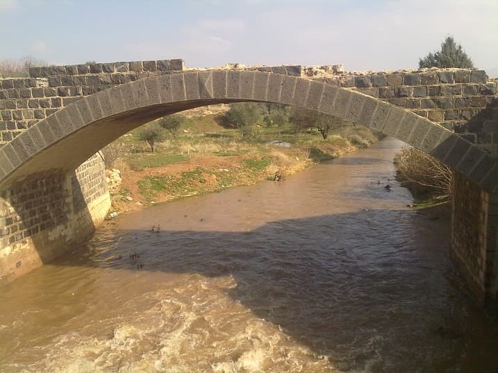
In some stretches the river is an earth channel; in others it is a fast stream running under stone bridges. In winter and spring the bed is full and the water runs brown. In the old village north of Sa’sa’, right on the bank, stands Khan Sa’sa’, a caravanserai from the Mamluk and Ottoman periods.
What most people miss
Khan Sa’sa’. The khan, a halt on the Damascus–Jerusalem road, was built on this river’s bank, and al-Luqaymi, who stayed there around 1731, wrote of sitting beside the Awaj. See the river from there, not as water on its own but as the reason for the road and the halt.
Tips
- Stay away from the source area around Arnah and Beit Jinn; choose the lower course near Sa'sa' and al-Kiswah
- Read it with the Barada River entry; the biblical verse names the two side by side
- In winter the water is fast and the banks are muddy; watch your footing going down
Transparency
- How this was chosen
- Written by hand; opening hours, entry fee and coordinates are kept as data. A field that is not known for certain is marked as variable rather than guessed.
- Facts checked
- September 2026
- Last updated
- September 15, 2026