Khan Dannun, a Mamluk Caravanserai on the Hajj Road
A basalt Mamluk caravanserai finished in 1376 south of Damascus, the pilgrim caravan’s stop after al-Kiswah. Its current state is unconfirmed; ask locally.
- Opening hours
- Could not be confirmed — ask on site
- Entry
- Variable — check on site
- Duration
- 30 minutes
- Best time
- A spring or autumn morning, on the same day as al-Kiswah
- Period
- Mamluk
- Address
- Khan Dannun town, 5 km south of al-Kiswah, Rif Dimashq
A Mamluk caravanserai (khan, a walled inn built around a courtyard) that gave its name to the town of Khan Dannun, 5 km south of al-Kiswah and south of Damascus. It was finished in 1376 and was the stop after al-Kiswah for the hajj caravan heading south from Damascus to Mecca. Apart from its vaults it is built of the dark basalt typical of the Hauran. Since 1949 the town has also held a Palestinian refugee camp. The khan’s present condition, and whether it is open to visitors, could not be confirmed.
Who built it
It was built by Manjak al-Yusufi, governor of Damascus, in the reign of the Bahri Mamluk sultan al-Ashraf Shaban. The architect was Ali ibn al-Badri, remembered as muhandis al-Sham, the engineer of Damascus. The name is the colloquial form of Dhul-Nun, a 9th-century Sufi.
Its place on the hajj road
The first stage out of Damascus was al-Kiswah, then Khan Dannun, then Ghabaghib. Much later the town became a stop on the Damascus to Hauran line of the Hejaz Railway. On the map, a bridge of the abandoned line passes right beside the khan.
How it was laid out
A square open courtyard, with livestock kept in the middle. Around it ran lodging rooms with arcades built on top of them. Round basalt towers flanked the courtyard. Inside was a small prayer room with a mihrab. A stream flowing east formed a marsh in front of the gate. When the Swiss traveller Johann Ludwig Burckhardt passed through in the early 19th century, he found the khan in ruins.
What you see today
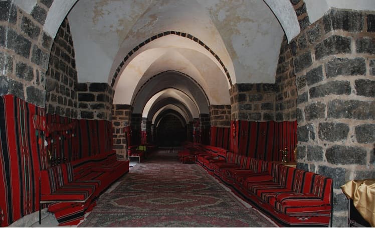
A photograph taken in 2010 shows a long hall with basalt walls and white plastered vaults, furnished with red cushions; at least part of the building had been repaired and was in use that year. No source was found for what happened after. The khan stands inside a town that has grown together with the camp, so ask on the spot before going.
Getting there
5 km south of al-Kiswah. The villages of al-Taybah lie to the west, Muqaylibah to the northwest and Khiyarat Dannun to the east. The khan has no outline of its own on the map; ask for it in town.
Do not miss
The line where wall meets vault. Sources say the building is basalt throughout except for the vaults; in the hall, the sharp edge where dark stone turns into pale vault is that fact made visible.
Tips
- Ask for the khan in town; it has no outline of its own on the map
- Pair it with al-Kiswah; the two stages are 5 km apart
- The camp is a residential area; ask before taking photographs
Transparency
- How this was chosen
- Written by hand; opening hours, entry fee and coordinates are kept as data. A field that is not known for certain is marked as variable rather than guessed.
- Facts checked
- September 2026
- Last updated
- September 15, 2026