The Phoenician Walls of Arwad Island
Giant stone blocks facing the open sea on Arwad’s west shore: what an 1853 survey measured, the rock-cut ditch, and what can still be seen of the wall today.
- Opening hours
- Open shoreline; ask the time of the last boat back when you board
- Entry
- No separate fee for the wall is known; ask the boat fare before boarding
- Duration
- 45 minutes
- Best time
- Spring and autumn afternoons, when the west-facing blocks catch the light
- Period
- Phoenician (exact date unknown)
- Address
- West shore of Arwad Island, Tartus
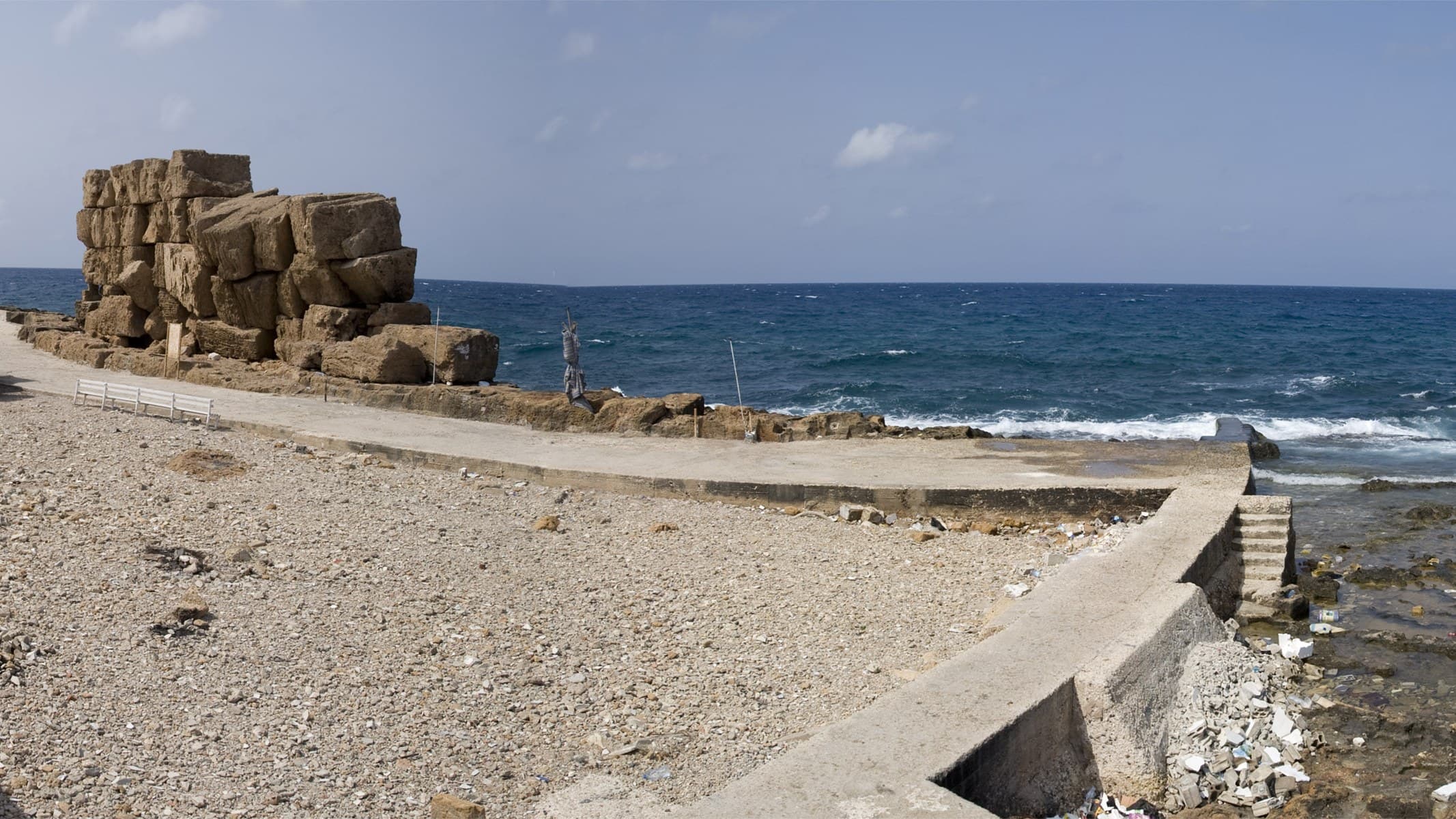
A wall of huge stone blocks, built against storms and attack, once ran all the way around Arwad, the island off Tartus. Sources call it the Phoenician wall; no firm construction date is known. It reads most clearly on the west side, facing the open sea. There the blocks sit stacked on the shore. Part of the wall is cut straight into the bedrock. This page covers only the wall, not the island as a whole.
Getting there
Boats from the jetty on the Tartus corniche cross to the island in about twenty minutes. They put in at the harbour on the east side. The west shore is a walk away through narrow lanes. The island is small, and crossing it does not take long. Tartus opened its 2026 tourist season in June with an official visit to the island, and the boat service is running.
What was measured in 1853
The most detailed description of the wall comes from a British naval officer. In an article in the Journal of the Royal Geographical Society in 1853, Captain William Allen described the huge remains of the old wall on three outer faces of the island. In two places, five or six courses still stood. The blocks were 15 and 18 feet long, close to five metres, and laid crosswise, so the length of each block gave the thickness of the wall.
On the west side the wall was cut into the bedrock up to a height of 8 to 10 feet. Only on this side, Allen writes, was the rock on the seaward edge cut into a ditch and a sloping outer face; the ditch was about 30 feet wide, roughly nine metres. In his view the aim was to break the force of the waves at the island’s most exposed point. He also noted a channel about a foot and a half wide, running under the wall down a gentle slope to the harbour. He took it to be a way of flushing the harbour clean, since there is almost no tide here.
Allen also quotes earlier travellers: in 1738 Pococke found very few houses outside the castles, and Volney wrote that not a single wall was left of the many-storeyed houses described by Strabo.
Who studied it later
The French writer Ernest Renan examined the island’s walls, houses, street junctions and tomb finds in 1860. Arabic Wikipedia counts the structure known on the island as Al-Burj al-Ahmar, the Red Tower, as a surviving part of the wall. In the 20th century the research moved underwater: Antoine Poidebard’s aerial survey of harbours included Arwad, and between 1963 and 1968 the underwater archaeologist Honor Frost studied the island’s monumental harbour and quay structures.
What can be seen today
Photographs taken in 2008 show, on the west shore right beside the coast road, a section of wall several courses high, made of roughly dressed giant blocks. In front of it runs a sandstone shore that the waves have cut into terraces. Traces of the old harbour areas show along the same coast. We found no recent source saying which parts of the wall can be reached on foot today. Look on site.
What most people miss
Look at the blocks from the side, at their ends. That is where Allen’s observation makes sense: the stones are laid across the line of the wall rather than along it, so the length of a single block tells you how thick the wall was. The castle in the middle of the island and the Ayyubid Tower by the harbour fit into the same day.
Tips
- Keep off the shore rocks in rough weather; the west side faces the open sea
- Study the blocks from the side: stones laid crosswise show how thick the wall was
- The castle in the middle of the island and the Ayyubid Tower by the harbour fit into the same walk
- Ask the time of the last boat back when you cross to the island
Transparency
- How this was chosen
- Written by hand; opening hours, entry fee and coordinates are kept as data. A field that is not known for certain is marked as variable rather than guessed.
- Facts checked
- September 2026
- Last updated
- September 15, 2026